Share October 2022 Kala'mas: Conservation on Facebook
Share October 2022 Kala'mas: Conservation on Linkedin
Email October 2022 Kala'mas: Conservation link
Conservation is one of many important topics being discussed and considered as part of the work that ‘Namgis is doing to update the land use and forest landscape plans for the Nimpkish Valley. Creating conservation areas is often done to protect and manage habitat to benefit different species of fish and wildlife, and ecosystems in general. For example, conservation areas may be created to protect species at risk, spawning and nesting areas, migration routes, and more. Identifying conservation areas can also be part of a strategy to protect Indigenous values and recreational uses.
In the portions of ‘Namgis territory that make up the Gwa’ni Project area, many important areas exist. The creation of conservation designations over some of these areas would protect a range of special values, including areas that have high cultural significance such as ancient habitation sites, archeological sites, and unique landscape features like caves. Including portions of the forest ecosystem located near rivers and streams, referred to as riparian areas, would protect the connectivity of rich valley bottoms across the landscape, allowing many species of plants and animals to thrive. Such a conservation network would include important fish habitat and rare plant communities. Areas that have previously been designated for old growth management, ungulate winter range, or wildlife habitat are also being examined and included in the new vision for conservation management within the Nimpkish Valley.
Implementing the vision of a network of conserved areas will better ensure that ‘Namgis needs are met and will add value to future ‘Namgis descendants use and enjoyment of the Nimpkish Valley.
As part of the work to develop consensus recommendations, the Gwa’ni Project Technical Team is looking at feedback from members as well as data collected from other technical sources on how these important areas may best be protected through the creation of conserved areas or other means.
There is still time for you to get involved! Visit the Gwa’ni Project Engagement Website, email your questions to Brian Svanvik at Brian.Svanvik@namgis.bc.ca, check out the posters that are up at Council Hall, and stay tuned for information coming about the community Open House happening soon in the Fall of 2022!
Share August 2022 Kala'mas: Gwa'ni Project Topics and Passive Open House on Facebook
Share August 2022 Kala'mas: Gwa'ni Project Topics and Passive Open House on Linkedin
Email August 2022 Kala'mas: Gwa'ni Project Topics and Passive Open House link
The Gwa’ni Project covers a large range of important topics. Here are some more details about topics that are being considered as part of the work that ‘Namgis is doing with the Province to update the land use plan for the Nimpkish Valley:
Land Use Designations
A simple way to understand land use planning is through land use designation zones and how different areas and natural resources are being managed, used, and protected by the land use plan. There are different types of land use designations that are currently used in the Nimpkish Valley:
- Protected Areas: Land where forest harvesting is not intended to occur and natural processes are generally left undisturbed.
- Low Intensity Resource Extraction Areas: Lands where environmental, recreational, and cultural values are prioritized, but logging will occur using harvest strategies that allow forests to grow older and remove lower volumes of timber.
- General Resource Management Zones: Land where logging activities occur following standard management strategies that attempt to balance timber values with environmental, recreation and cultural values.
- High Intensity Resource Extraction Areas: Land where logging activities have a higher priority, with the expectation that timber harvest could impact environmental, recreational and cultural values.
Through the work of the Gwa’ni Project, and with input from members, the Gwa’ni Project Technical Team will likely recommend that some of these designations change to better protect areas that are important while creating a balance between ‘Namgis values and economic and recreational activity in the Valley.
Aquatic habitats and riparian zones
Some of the most popular places that members visit in the Valley are the aquatic areas. Places like lakes, rivers, fish habitats and riparian areas (i.e., the forest ecosystem near natural water bodies) are often very rich habitats for plants and animals that rely on forest connectivity, which allows animals to move around and adapt to different environments. As part of the work to develop consensus recommendations, the Gwa’ni Project Technical Team is looking at data collected from a variety of sources over time including data from past ‘Namgis projects, speaking with members, and making decisions about how best to protect these important areas.
Forest values
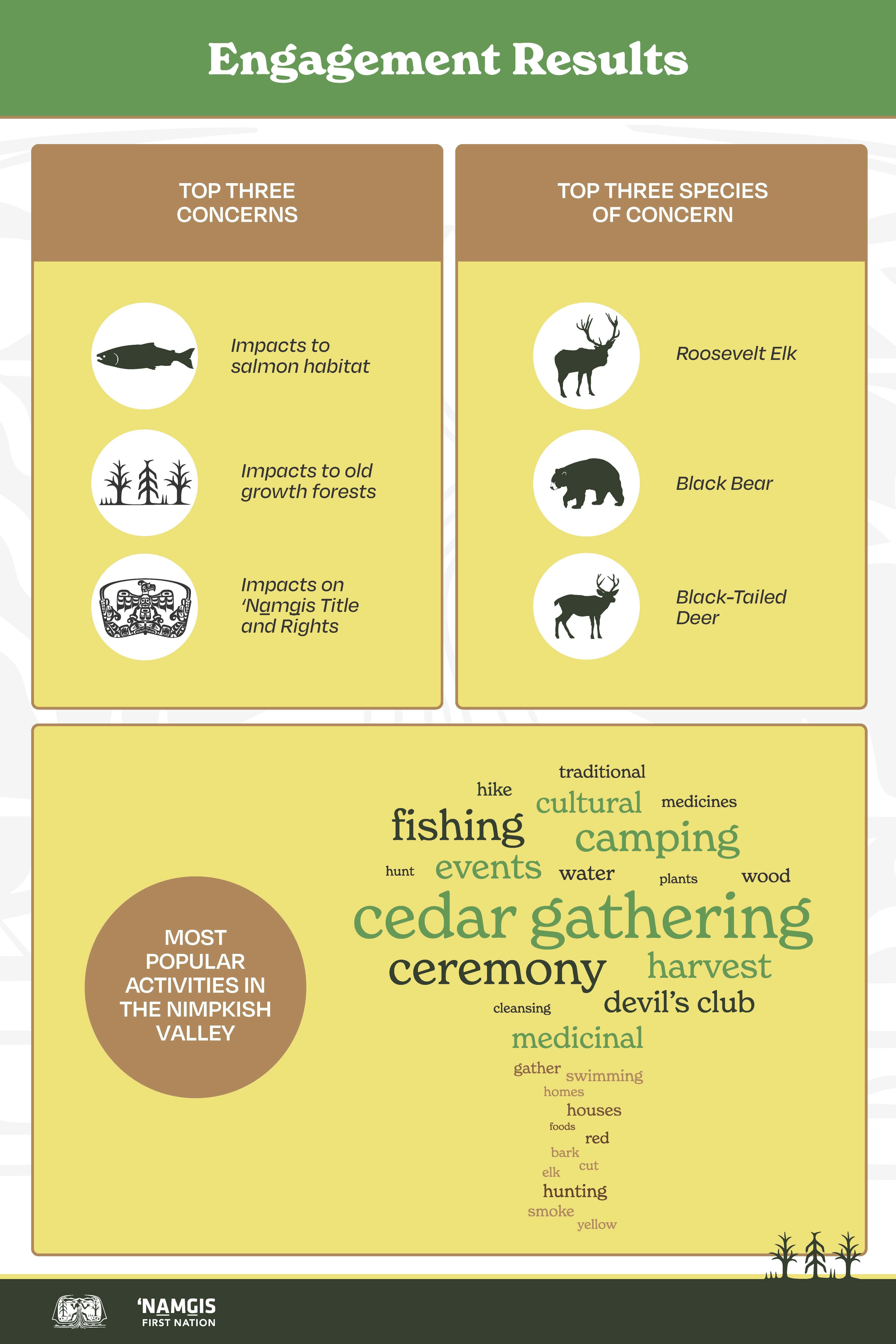
‘Namgis members currently visit the Nimpkish Valley to gather things like cedar bark, devil’s club, mushrooms, and other plants and medicines. Protecting each of these plants and the areas they grow in is important for the health of the forest and to ensure that the Valley can be used for many generations to come.
These are just a few of the key topics that the Gwa’ni Project Technical Team are continuing to consider as they develop their consensus recommendations. As the project progresses, the Technical Team are using different forms of data, including input from ‘Namgis members about their land use planning perspectives and priorities.
There is still time for you to get involved! Check out the posters that are up at Council Hall, and stay tuned for information coming about the community Open House happening in the Fall of 2022!
Share July 2022 Kala'mas: An Update on the Gwa’ni Project! on Facebook
Share July 2022 Kala'mas: An Update on the Gwa’ni Project! on Linkedin
Email July 2022 Kala'mas: An Update on the Gwa’ni Project! link
Last year, the Gwa’ni Project Team heard from members on many land use topics through the Gwa’ni Project website, a members survey and an open house. Thank you to everyone who contributed so far! If you are interested in learning more, we have combined all responses into a ‘Namgis What We Heard report, which is on the Gwa’ni Project website.
Since the Gwa’ni Project is a Government-to-Government partnership, the Province has also been engaging with stakeholders in the North Island through a survey and virtual focus groups. The responses from that engagement is available on a BC Government website in their engagement report: Gwa'ni Project What We Heard
Members of the Technical Team regularly report to, and receive feedback from, the Steering Committee, which includes leadership from ‘Namgis and the Province. This year, we are planning more engagement opportunities for members and are undertaking the third phase of a Socio-Economic Environmental Assessment (SEEA), which is an important element of the project to help decision-makers understand the potential positive and negative effects of various land use directions. In the fall of 2022, the SEEA will begin its third and final phase.
Gwa’ni Project and Forest Landscape Planning – Desired Future Forest Condition
Based on the input received from members and ‘Namgis leadership; we know how important it is to recognize the cultural values of the Nimpkish Valley. More specifically, the Technical Team is considering the management of various ecosystems. Cedar is recognized as being especially precious, and trees of all ages help maintain the full natural function of the forest. The long-term availability of large cedar is important to ensure that future generations are able to harvest cedar for traditional uses such as carving poles and canoe logs.
In addition to cedar, devil’s club and other medicinal plants need to be managed to ensure they remain available for use by present and future generations of ‘Namgis, and to contribute to the health and function of the larger forest ecosystem. Once again, we want to thank everyone who took time to participate in the engagements last year to provide this crucial information. We hope that we will hear from even more people in the upcoming year.
The Gwa’ni Project Team is considering the feedback that ‘Namgis members have provided about existing land use designations. The Project Team is developing recommendations that could change some zoning areas to better recognize the significance of the Nimpkish Valley’s aquatic resources, especially fish and fish habitats. The new zoning will be designed to increase the protection of forests and cultural values near streams and other types of aquatic features. Better protection of those areas will also support the resiliency of plant and animal populations by creating greater forest connectivity, which allows species to move and adapt less inhibited.
We hope you have been able to participate in the various in-person and online engagement activities that have taken place thus far, including last November’s Open House, and online through the Gwa’ni Project website!
Share Update and Engagement Report! on Facebook
Share Update and Engagement Report! on Linkedin
Email Update and Engagement Report! link
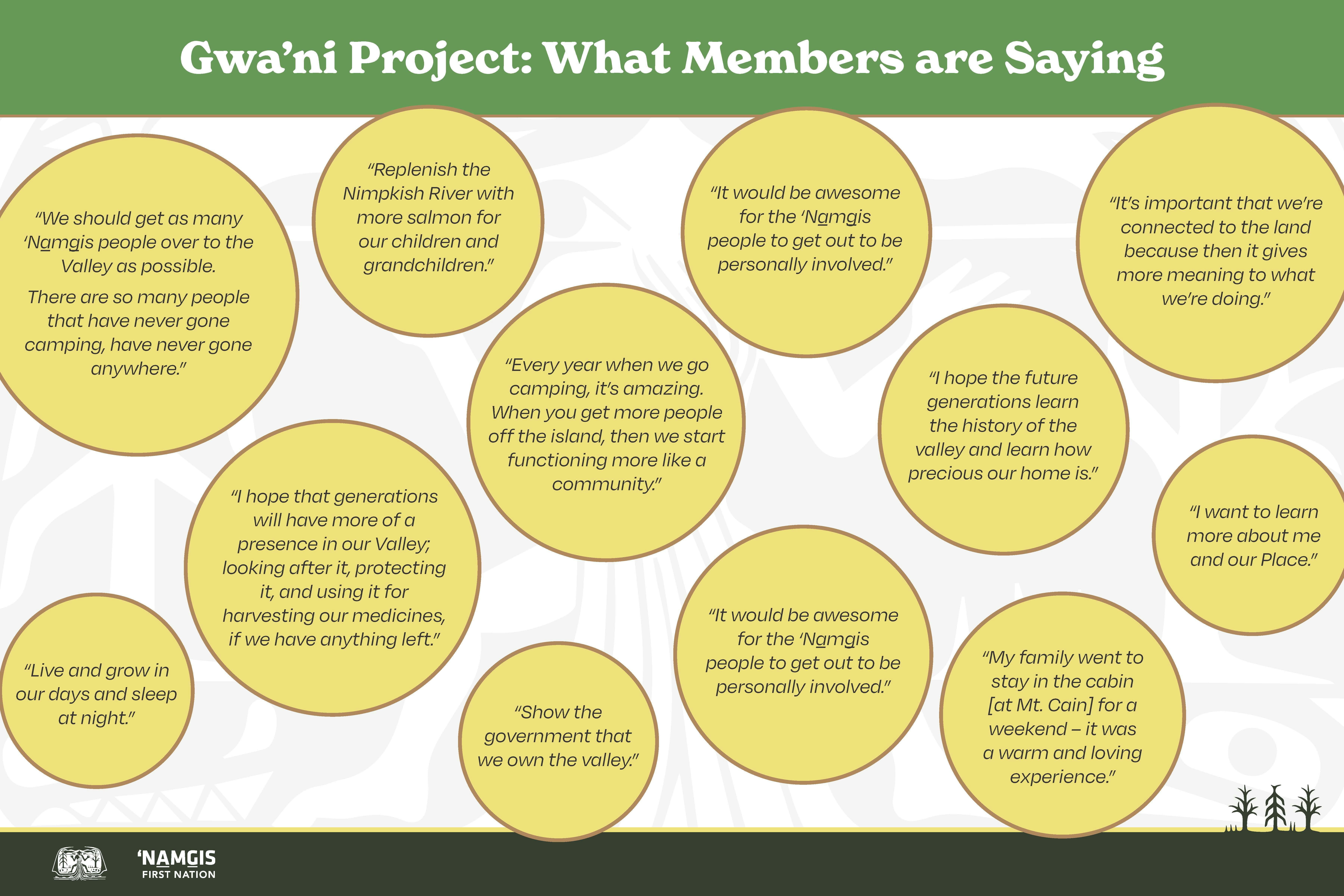
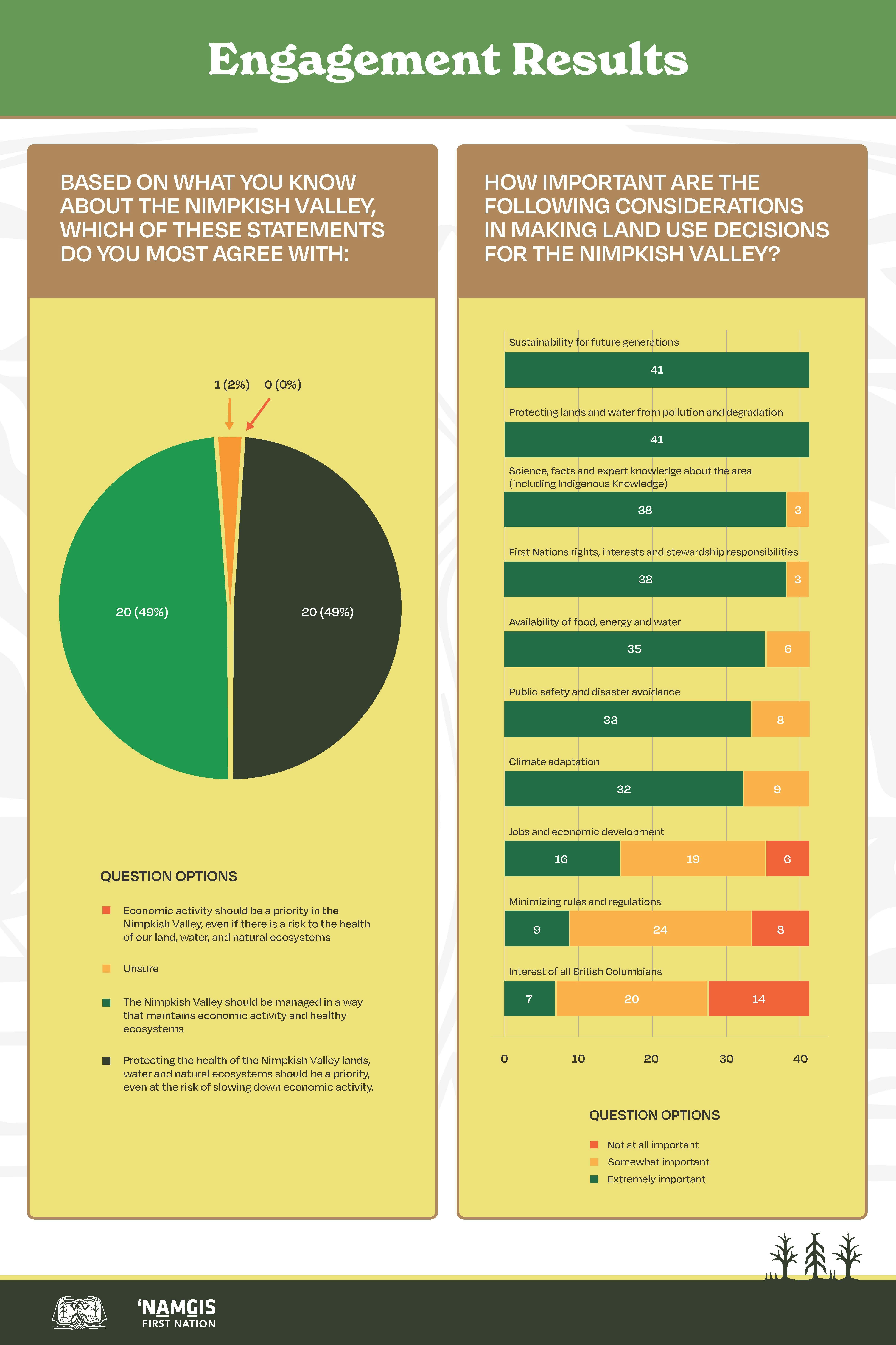
Last fall, we started our first of many engagement activities for this project, including a community survey and a community open house. We talked to members about how they use the Nimpkish Valley and what is most important to them as we work with the Province on recommendations for a new land use plan.
All the feedback from those activities were compiled into an engagement report, which is now ready to read! The report provides information about the project, the activities we did, and summarizes the survey results and what was shared during the open house.
Thank you to everyone who has participated and shared what is important to them when it comes to land use planning in the Nimpkish Valley.
Read the full report by following this link: https://engage.namgis.bc.ca/22670/widgets/109156/documents/78882
Share End of Year Gwa’ni Project Update on Facebook
Share End of Year Gwa’ni Project Update on Linkedin
Email End of Year Gwa’ni Project Update link
The Gwa’ni Project is well underway, and a great deal of progress has been made. The Gwa’ni Project online engagement hub has been launched as a space for ‘Namgis members to go to learn about the project, share their ideas, and participate in various engagement activities.
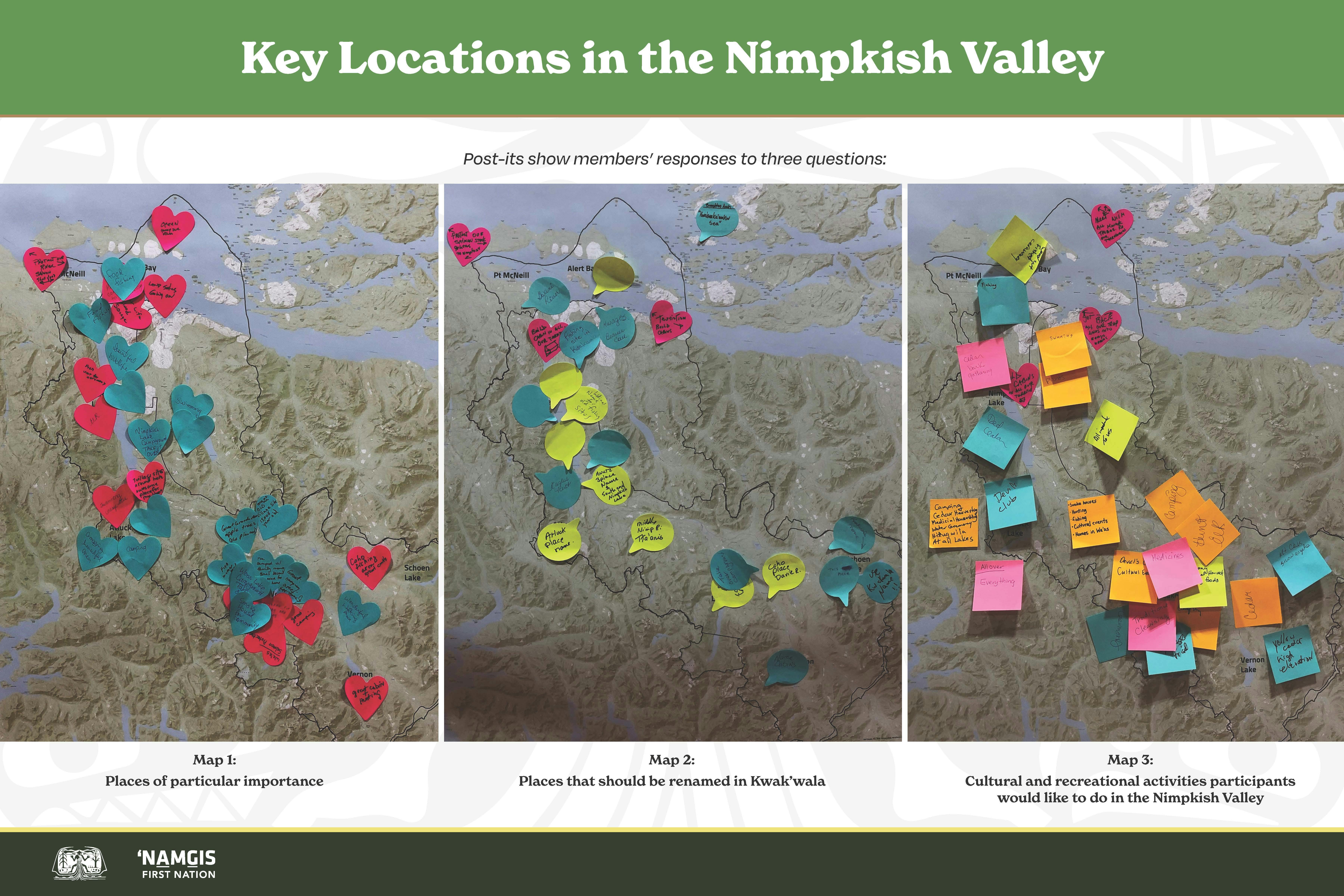
In late November, we hosted a members-only Open House for members to attend and participate in a series of engagement activities. Just about 50 people joined us on November 23 and provided important input including how they wish they could spend time in the Valley, where they think place names should be re-named in Kwak’wala and how they think land should be used in future generations. We also had a storytelling station where people could share their memories and hopes for the valley as this work continues. We also heard engaging questions from members about recreational facilities, wildlife and habitat monitoring and new or renewed programs in the valley that will help inform the Gwa’ni Project.
We are envisioning and planning for the future of the Nimpkish Valley by continuing to collect feedback from members, sharing the results of that feedback, and building upon it as we work towards a land use plan for the Nimpkish Valley.
Thank you to all members who have participated and contributed to the Gwa’ni Project thus far – your ideas are very important and valuable to the land use planning process!
Share Kala'mas August 2021: What is VLUP and joint recommendations? on Facebook
Share Kala'mas August 2021: What is VLUP and joint recommendations? on Linkedin
Email Kala'mas August 2021: What is VLUP and joint recommendations? link
The following article about the Gwa'ni Project was shared in the August 2021 issue of Kala'mas, 'Namgis First Nation's community newsletter.
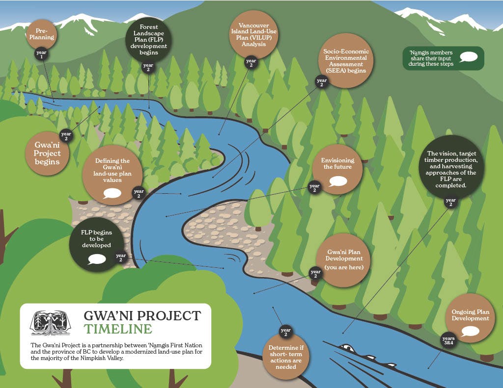
‘Namgis First Nation is partnering with the B.C. government to develop a modernized land-use plan for the majority of the Nimpkish Valley. This process will take several years to complete and is being called the Gwa’ni Project. The final land use plan recommendations will cover most of the Nimpkish Valley. They will guide what can happen on lands, rivers, lakes, watersheds, and forests in the planning area.
The Gwa’ni Project will create consensus recommendations on how to update the old plan – the Vancouver Island Land Use Plan.
VILUP – the Vancouver Island Land-Use Plan
The Vancouver Island Land Use Plan was enacted in 2000. It was the first time land use planning was done at such a large scale over an entire region in B.C. The plan protected approximately 13% of all land in the region and opened close to 81% of the land for potential uses like logging, recreation, tourism, mining, and other resource extraction.
A new, modernized land use plan could replace or amend VILUP in the Nimpkish Valley region. It will guide what can happen on lands, rivers, lakes, watersheds, and forests in the Gwa’ni Project area, which covers most of the Valley. ‘Namgis is partnering with B.C. on the Gwa’ni Project to develop consensus recommendations about land uses in this portion of ‘Namgis territory.
The Gwa’ni Project Team’s “Consensus Recommendations.”
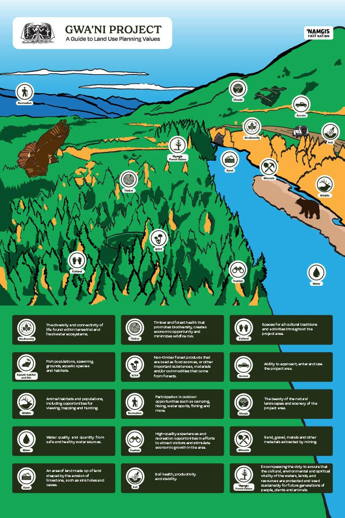
Throughout the Gwa’ni Project, ‘Namgis members will asked for input into how our lands and waters in the planning area should be managed for future generations. Members will be asked for feedback on ways to manage activities and protect resources in the Nimpkish Valley such as:
- Tourism
- Recreation
- Mining
- Forestry
- Medicine and bark harvesting
- Fish and wildlife
- Cultural sites
- Plants, trees, animal habitats
- Rivers, lakes, watersheds
- Caves/karst
Technical experts and leaders representing ‘Namgis and B.C. make up the Gwa’ni Project team. They will use member feedback to develop consensus recommendations to inform a modernized land use plan. All ‘Namgis members will be encouraged to give their input so that the final recommendations reflect our Nation’s values and interests.
Forestry Landscape Plan – FLP
Land-use plans give broad, strategic level direction about managing resources and land development. More specific, tactical plans are created from them to guide how the forestry industry will operate inside the area that a land use plan covers. If, for example, a land-use plan is likened to the foundation of a house, these other plans drawn from that land-use plan are like the frames and walls of a house.
Most of the area of the Nimpkish Valley that the Gwa’ni Project deals with is within Western Forest Product’s Tree Farm Licence 37 (TFL 37). As ‘Namgis and BC develop consensus recommendations to modernize the VILUP, a Forestry Landscape Plan (FLP) is being developed that will get specific about things like:
- When, where, and how trees will be harvested
- Where logging roads will be built
- How forest practices will consider and manage all the forest’s values, including wildlife, fish, and aquatic habitats.
As the Gwa’ni project moves forward, ‘Namgis members will also be invited to share their feedback into the development of the FLP. We are hopeful that once the project is complete, we will have several recommendations and an FLP that reflect our people’s vision, values, and priorities for the future of our lands, and that result in our lands being managed sustainably for future generations.
Share The Story of Gwa'nalalis and the Gwa'ni River on Facebook
Share The Story of Gwa'nalalis and the Gwa'ni River on Linkedin
Email The Story of Gwa'nalalis and the Gwa'ni River link
Pal’nakwalagalis Wa’kas (Dan Cranmer) shared the Gwa'ni River story in 1930:
When the Transformer (or Creator), Kaniki’lakw, travelled around the world, he was eventually returned to the place where Gwa’nalalis lived. In an earlier encounter, the Transformer had beaten Gwa’nalalis, who was ready for his return. Kaniki’lakw asked, “Would you like to become a cedar tree?”
Gwa’nalalis replied, “No, Cedar trees, when struck by lightning, split and fall. Then they rot away for as long as the days dawn in the world.”
Kaniki’lakw asked again, “Would you like to become mountain?”
“No”, Gwa’nalalis answered, “For mountains have slides and crumble away for as long as the days dawn in the world.”
The Transformer asked a third question. “Would you like to become a large boulder?”
Again, Gwa’nalalis answered, “No. Do not let me become a boulder, for I may crack in half and crumble away as long as the days dawn in the world.”
Finally, Kaniki’lakw asked, “Would you like to become a river?”
“Yes, let me become a river that I may flow for as long as the days shall dawn in the world,” Gwa’nalalis replied. Putting his hand on Gwa’nalalis’ forehead and pushing him down prone, Kaniki’lakw said, “There, friend, you will be a river and many kinds of salmon will come to you to provide food for your descendants for as long as the days shall dawn in the world.”
And so the man Gwa’nalalis became the river, Gwa’ni.
Share Kala'mas Spring 2021 Article - Modernized Land Use Plan on Facebook
Share Kala'mas Spring 2021 Article - Modernized Land Use Plan on Linkedin
Email Kala'mas Spring 2021 Article - Modernized Land Use Plan link
The following article about the Gwa'ni Project was shared in the spring 2021 issue of Kala'mas, 'Namgis First Nation's community newsletter.
‘Namgis First Nation is partnering with the B.C. government to develop a modernized land-use plan for the majority of the Nimpkish Valley. This process will take several years to complete and is being called the Gwa’ni Project. The memorandum of understanding will allow us to share recommendations with the Province on how our resources and lands should be managed for future generations. The final land-use plan will cover lands from the mouth of the Nimpkish River to the Vernon Lake watershed. It will guide what can happen on lands, rivers, lakes, watersheds, and forests in the planning area. This announcement marks the beginning of this project and no decisions about land use in the territory have been made. We will continue to share information on the project as it progresses, and all members will have an opportunity to engage in the process so that the recommendations reflect our Nation’s values and interests.
FAQ
What is the Gwa’ni Project ?
The ‘Namgis First Nation is partnering with the B.C. government to modernize land use planning in the Nimpkish Valley. This project will take several years to complete. It will allow ‘Namgis to share recommendations with the Province on how our resources and lands should be managed for future generations.
We are optimistic about this opportunity to work with B.C. in this collaborative way. It will be a big step towards ‘Namgis exercising our inherent rights over our territories.
What area will the land-use plan cover?
The plan will cover lands from the from the mouth of the Nimpkish River to the Vernon Lake watershed.
What will the land-use plan be about?
The Gwa’ni land-use plan will guide what can happen on lands, rivers, lakes, watersheds, and forests in the planning area. The plan will also detail areas that will be protected, and how.
A simple way of thinking about a land-use plan is zoning – the plan will tell people, communities, and industries how to manage and protect resources and activities like:
- Forests
- Rivers
- Lakes
- Watersheds
- Fish and wildlife
- Caves/karst
- Medicine and bark harvesting
- Important cultural sites
- Tourism
- Recreation
- Mining
- Forestry
How long will this process take?
Land-use planning takes several years to complete. There are five steps in the B.C. land-use planning process and the Gwa’ni project is entering the second step. The five steps are called:
- Pre-planning
- Plan initiation
- Plan development
- Plan evaluation and approval
- Implementation and monitoring
Why is this important to ‘Namgis?
Participating in this process is a step towards restoring our voice and authority over long-term decisions made on behalf of our lands and territories.
During the comprehensive community planning process, members expressed the importance of developing a territorial plan and ensuring that ‘Namgis is making decisions about how land is used within our territory. This collaboration with the B.C. government is one of the ways we are fulfilling those priorities.
We are hopeful that this new partnership with the Province will give us a strong voice to determine how lands, rivers, lakes, watersheds, and forests in the Gwa’ni project area can be used and protected.
How can I get involved?
We will share information about the project as it moves forward. All members will have a chance to share their input during different stages of the project.
Share 'Namgis and B.C. Sign MOU to Partner on Modernized Land-Use Planning on Facebook
Share 'Namgis and B.C. Sign MOU to Partner on Modernized Land-Use Planning on Linkedin
Email 'Namgis and B.C. Sign MOU to Partner on Modernized Land-Use Planning link
For Immediate Release
Feb. 25, 2021
‘Namgis, Province partner as stewards of lands and resources
ALERT BAY - The Province and 'Namgis First Nation have signed an agreement to partner on a modernized land use planning approach to manage the integrity of the ecosystems and natural resources in 'Namgis territory.
Katrine Conroy, Minister of Forests, Lands, Natural Resource Operations and Rural Development, and Don Svanvik, 'Namgis Chief Councillor, have signed a government-to-government memorandum of understanding designed to help sustain the lands, waters, resources and wildlife in a manner consistent with implementation of the United Nations Declaration on the Rights of Indigenous Peoples and B.C.'s Declaration on the Rights of Indigenous Peoples Act.
The agreement will guide land use planning to protect and manage the integrity of the ecosystems that sustain the lands, waters resources and wildlife the 'Namgis rely on to exercise their Aboriginal title and rights.
The process will also support the economic and social well-being of 'Namgis, communities and stakeholders who use and rely on the resources contained in the project area, which extends from the mouth of the Nimpkish River to the Vernon Lake watershed on northern Vancouver Island.
The Gwa'ni Project area encompasses more than 166,000 hectares, including the majority of the Upper and Lower Nimpkish Landscape units. Most of the area is within Tree Farm Licence 37, which is held by Western Forest Products Inc. In 2018, B.C. dedicated $16 million over three years to modernize land use planning to help advance reconciliation efforts with Indigenous communities, support economic opportunities, and make sure the stewardship of provincial public land reflects the diverse values and interests of all British Columbians.
The next step in the Gwa'ni Project will be community and stakeholder consultation in spring 2021.
Link to Information Bulletin


 Gwa'ni Project Information Package for 'Namgis Members (June 2022) (8.6 MB) (pdf)