'Namgis Forest Planning
‘Namgis First Nation is partnering with the B.C. government to support developing a modernized land use plan, which will cover most of the Nimpkish Valley. Our work with the province is called the Gwa’ni project. The project will result in joint recommendations to better protect resources including rivers, lakes, watersheds and forests in portions of ‘Namgis territory that are in the land use plan area, while supporting a successful, sustainable forestry economy.
Over the coming weeks, months, and years, ‘Namgis wants to hear from as many of our members as possible to develop joint recommendations that properly reflect our Nation’s values and interests. This website is a virtual forum for ‘Namgis members to keep up to date with the progress on the Gwa’ni project and share their feedback and ideas about the future of land-use planning in the Gwa’ni region.
The Meaning Behind the Name "Gwa'ni"
Gwa'ni is what our people named the river currently called the Nimpkish. The name honours our ancestor Gwa’nalalis, who became the river. (Nimpkish itself is an anglicized terms referring to 'Namgis). This land-use planning project is called Gwa'ni to recognize that, for millennia, our people have been living on the lands and waters in the planning area.
Click here to read the story of Gwa'nalalis.
Explore the Gwa'ni Project Land Use Planning Values here!
-
Accessing cedar in the Nimpkish Valley
Share Accessing cedar in the Nimpkish Valley on Facebook Share Accessing cedar in the Nimpkish Valley on Twitter Share Accessing cedar in the Nimpkish Valley on Linkedin Email Accessing cedar in the Nimpkish Valley link
During engagements, 'Namgis members have shared that they don’t always know where to access cedar and other medicinal plants like Devil's Club in the Nimpkish Valley.
Both red and yellow cedar can be found abundantly throughout the Nimpkish Valley. Generally, cedar thrives in moist environments and often in the shade of other trees. These optimal growth conditions support the development of healthy and vibrant cedar trees. When exploring the Nimpkish Valley, keep an eye out for areas with these characteristics!
Explore the Gwa’ni Project Engagement Site to learn more about what the Technical Team has been up to, and what is coming next for the Gwa’ni Project!

-
Cedar as a Land Use Planning Value
Share Cedar as a Land Use Planning Value on Facebook Share Cedar as a Land Use Planning Value on Twitter Share Cedar as a Land Use Planning Value on Linkedin Email Cedar as a Land Use Planning Value linkDuring community engagements, 'Namgis members shared about the many ways cedar is important in their lives. In response to this feedback, cedar has been added as a planning value of the Gwa’ni Project, helping to shape the ways that the project and its consensus recommendations strikes a balance between various land use planning considerations.
In the context of the Gwa’ni Project, cedar – wilkw, which is considered the “tree of life”, provides all its parts such as roots, bark, wood, and branches for use within ‘Namgis culture. It is the official tree of the Province and is a valuable resource throughout B.C.

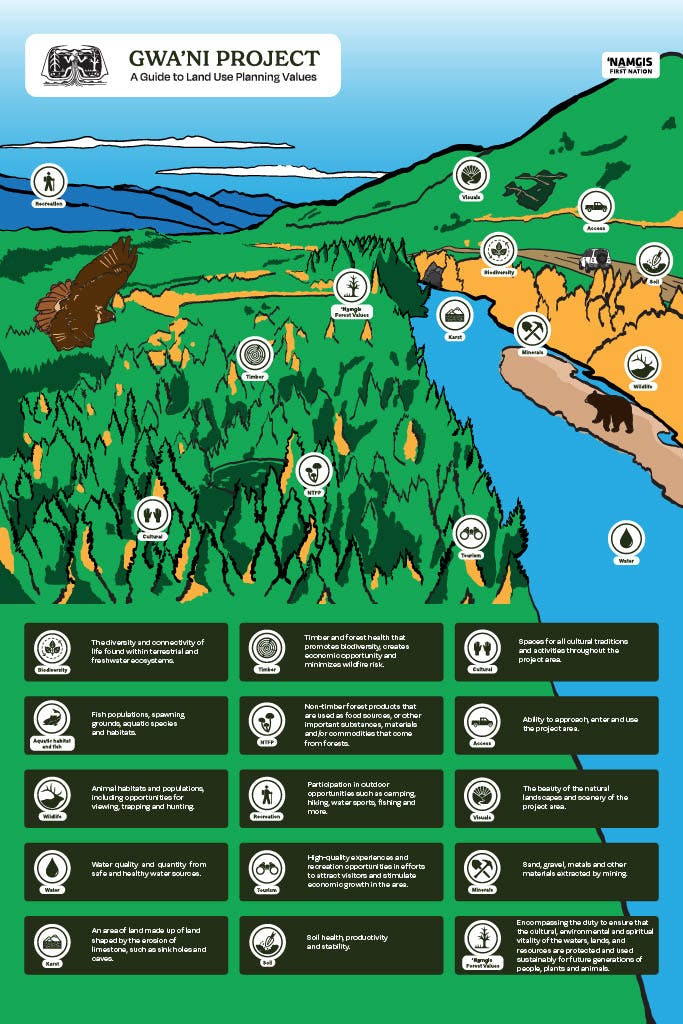
This infographic shares all of the land use planning values guiding the Gwa’ni Project, including the newly added cedar value. Together, these values represent the different considerations that are guiding the project's decisions and actions.
-
Prioritizing Ecological Integrity
Share Prioritizing Ecological Integrity on Facebook Share Prioritizing Ecological Integrity on Twitter Share Prioritizing Ecological Integrity on Linkedin Email Prioritizing Ecological Integrity linkThe Gwa'ni Project is proposing the creation of the Gwa’ni Special Management Zone (SMZ). Special Management Zones are intended to prioritize other values and ecological integrity over timber. To help achieve these outcomes, we are proposing redesigning and increasing the amount of special management zones in the Nimpkish Valley to prioritize ecological integrity over forestry.
Strategies developed through the FLP, considered within the special management zone, will include:
- Smaller harvest areas
- Increased retention (more trees and patches left standing)
- Longer rotation between harvest (allowing trees to grow older before harvest)
- No herbicide use for forestry purposes
- Ending clearcut harvest (instead use retention silviculture systems and alternative approaches)
Through the Gwa’ni Project engagements, we have also heard concerns regarding the health and availability of cedar for future generations, given the cultural importance cedar holds. One of the goals of the SMZ is to allow more time for cedar to grow naturally and allowing it to take its time to grow.

-
There are many ways to describe and talk about cedar in Kwak̓wala!
Share There are many ways to describe and talk about cedar in Kwak̓wala! on Facebook Share There are many ways to describe and talk about cedar in Kwak̓wala! on Twitter Share There are many ways to describe and talk about cedar in Kwak̓wala! on Linkedin Email There are many ways to describe and talk about cedar in Kwak̓wala! link Discover the many expressions for cedar by checking out the First Voices webpage which has been developed in part by ‘Namgis members: https://www.firstvoices.com/kwakwala/Do you know any others that aren’t included in this list? Let us know!
 -
November 2023: Uses for Cedar
Share November 2023: Uses for Cedar on Facebook Share November 2023: Uses for Cedar on Twitter Share November 2023: Uses for Cedar on Linkedin Email November 2023: Uses for Cedar link
‘Namgis forest values, trees, and plants are important elements being considered by the ‘Namgis Technical Team.
‘Namgis forest values are encompassing the duty to ensure that the cultural, environmental and spiritual vitality of the waters, lands, and resources are protected and used sustainably for future generations of people, plants and animals.
One of the very important forest species that is currently being discussed is cedar. Both red and yellow cedar live and thrive within various parts of ‘Namgis territory, and the roots, bark, wood, and branches of cedar trees are used for everyday uses as well as for ceremonial purposes.
Generally, cedar grows best in moist environments and when beneath the shade of other trees. These conditions allow for the trees to maintain healthy populations for generations of ‘Namgis to be able to sustainably harvest and use the bark for all different purposes.
Have any more questions about the Gwa’ni Project and Forest Landscape Plan? Email Brian Svanvik at Brian.Svanvik@namgis.bc.ca in the Natural Resources Department.

-
October 2023: Cedar and the Gwa’ni Project
Share October 2023: Cedar and the Gwa’ni Project on Facebook Share October 2023: Cedar and the Gwa’ni Project on Twitter Share October 2023: Cedar and the Gwa’ni Project on Linkedin Email October 2023: Cedar and the Gwa’ni Project linkCedar plays a crucial role within ‘Namgis way of life, including the creation of textiles, building materials, and carving wood for transportation and canoes.
There are three key cedar strategies the ‘Namgis Technical Team is recommending:
- Conserved areas: Conserved areas are designated spaces set aside to safeguard and preserve specific species, habitats, and ecosystems, including the protection of cedar trees. They are designed to promote connectivity and biodiversity within ecosystems.
- ‘Namgis Conservation Network: spans whole length of the Nimpkish watershed, surrounding major water areas/lakes and including areas of good cedar growing sites. Creating a network of connectivity, to restore forests, with a particular focus on cedar.
- Retention and reforestation: When designing harvest areas, large cedar trees and cedar groves are identified and protected in patches along with other trees and plants. Cedar is also planted everywhere it is ecologically viable.
The Gwa’ni Project aims to reflect the importance of protecting special cedar areas and engaging in retention strategies while also allowing for responsible timber harvesting.
Have any more questions about the Gwa’ni Project and Forest Landscape Plan? Email Brian Svanvik at Brian.Svanvik@namgis.bc.ca in the Natural Resources Department.

-
September 2023: The Upper Nimpkish area for conservation
Share September 2023: The Upper Nimpkish area for conservation on Facebook Share September 2023: The Upper Nimpkish area for conservation on Twitter Share September 2023: The Upper Nimpkish area for conservation on Linkedin Email September 2023: The Upper Nimpkish area for conservation linkIn addition to the proposed Lower Nimpkish area for conservation, the Gwa’ni Project is proposing the creation of a second conserved area. The proposed Upper Nimpkish area for conservation spans 880 hectares.
Here is more of what you need to know:
Ecological restoration
- The proposed Upper Nimpkish area for conservation includes many important areas including the mouth of the Yookwa River, which used to be a vital spawning ground for sockeye salmon. In part due to previous logging practices, the river has suffered substantial damage, disrupting its natural processes. In order for nature to restore itself, it will take time. The proposed Upper Nimpkish area for conservation aims to allow for that to occur.
- The Upper Nimpkish Conserved Area will contribute to stabilizing the existing 15-hectare Nimpkish River Ecological Reserve and its unique biodiversity
- The Upper Nimpkish Conserved Area will support:
- Key brood stock collection sites for the Gwa'ni Hatchery
- Salmon habitat restoration sites
- Protection of bear and bird species habitats
Recreation
- Accessible by road, the Upper Nimpkish conserved area connects to the road to Gold River, and routes to Woss
- The Vernon Lake campsite is also included in the proposed area
Have any more questions? Email Brian Svanvik at Brian.Svanvik@namgis.bc.ca in the Natural Resources Department and learn more about the conserved areas and more!

-
August 2023: The Lower Nimpkish area for conservation
Share August 2023: The Lower Nimpkish area for conservation on Facebook Share August 2023: The Lower Nimpkish area for conservation on Twitter Share August 2023: The Lower Nimpkish area for conservation on Linkedin Email August 2023: The Lower Nimpkish area for conservation linkThe Gwa’ni Project is excited to share more about the proposed Lower Nimpkish area for conservation!
Spanning approximately 780 hectares, one of the primary goals of the proposed Lower Nimpkish area for conservation is to ensure the long-term preservation of 'Namgis cultural heritage, fish values and biodiversity.
Here is more of what you need to know about the proposed Lower Nimpkish area for conservation:
- Aims to protect and preserve important archaeological and cultural sites, including traditional village sites, fish weirs, and a defensive point
- The southern end is accessible by road and in general, the proposed area surrounds the Lower Nimpkish Provincial Park, which is currently difficult to access
- Close to three 'Namgis IR’s - Ar-Ce-Wy_Ee #4, Ches-La-Kee #3, and O-Tsaw-Las #5
The proposal to conserve this area removes this section of land from the area currently considered available for timber harvesting. To learn more, email your questions to Brian Svanvik at Brian.Svanvik@namgis.bc.ca.

-
July 2023 Kala'mas: Conserved Areas
Share July 2023 Kala'mas: Conserved Areas on Facebook Share July 2023 Kala'mas: Conserved Areas on Twitter Share July 2023 Kala'mas: Conserved Areas on Linkedin Email July 2023 Kala'mas: Conserved Areas linkBuilding on what we’ve heard from members, the ‘Namgis Technical Team is actively working towards protecting wildlife, fish habitats, rare plant communities, and medicines of the Nimpkish Valley. As a key part of the project, we are pleased to introduce the ‘Namgis Conservation Network as a key component of work to increase existing ecosystem protection and to conserve key culturally significant sites.
Let's dig deeper into what conserved areas are and what they mean for the future of the Nimpkish Valley.
What is a conserved area?
The purpose of conserved areas is to protect cultural values, recreation areas, and manage the ecological integrity and biodiversity of existing habitats for present and future generations. By creating conserved areas, we are able to better preserve the homes of species of fish and wildlife from human activities such as timber harvesting. Examples of reasons for creating proposed areas for conservation include:
- Protecting habitat for fish species and wildlife
- Preserving rare plants and medicine
- Supporting ecosystems balance
Conservation is one of many important parts of the work that ‘Namgis is doing to update the Nimpkish Valley land use plan. Have any more questions about the Gwa’ni Project and Forest Landscape Plan? Email Brian Svanvik at Brian.Svanvik@namgis.bc.ca in the Natural Resources Department.

Gwa'ni Project 2021-2024 Engagement Report

Future Forest Outcomes
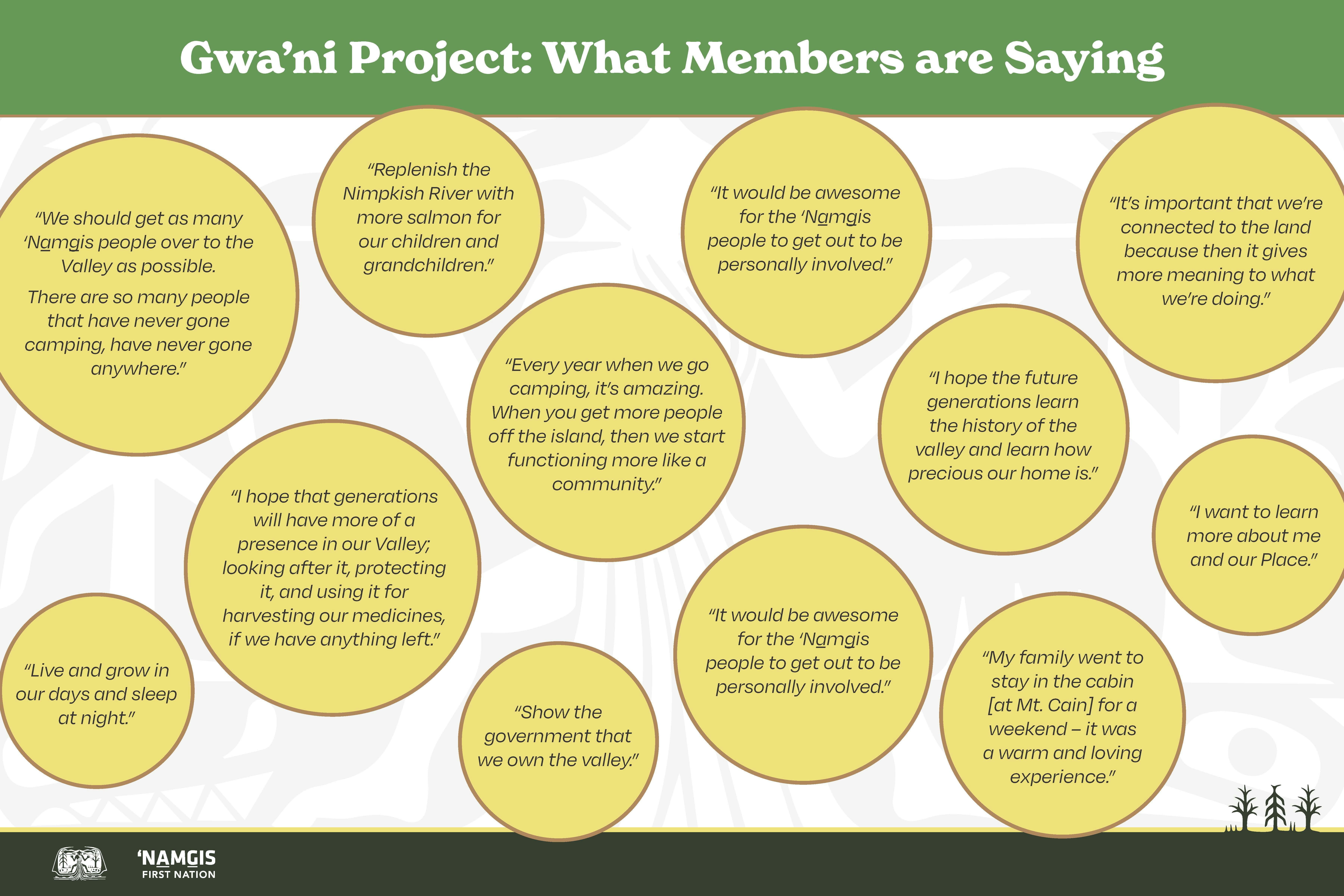
'Namgis Members' Reflections on the Nimpkish Valley

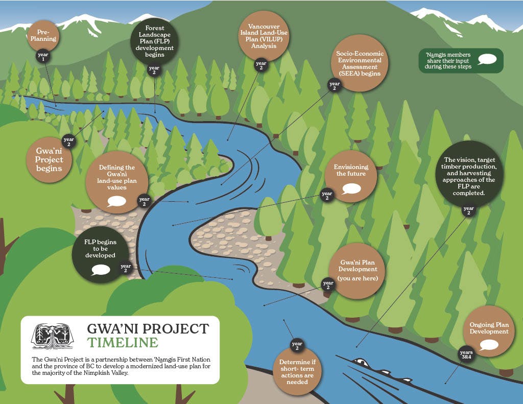
Gwa'ni Project Timeline and Values
Gwa'ni Project - Background Documents
-
 2024 Final Gwa'ni Project Community Engagement Report (5.13 MB) (pdf)
-
2022 Gwa'ni Project Information Package for 'Namgis Members (8.6 MB) (pdf)
-
2022 Gwa'ni Project Overview (1.74 MB) (jpg)
-
2022 Gwa'ni Project FAQs (1.37 MB) (jpg)
-
2021 Gwa'ni Project Overview (5.65 MB) (pdf)
-
2021 Gwa'ni Project Community Engagement Report (1.22 MB) (pdf)