'Namgis Forest Planning
During ‘Namgis comprehensive community planning, completed in 2017, we heard from members that it is crucial to develop a territorial plan and ensure that ‘Namgis is making all decisions about the use of land within the territory.
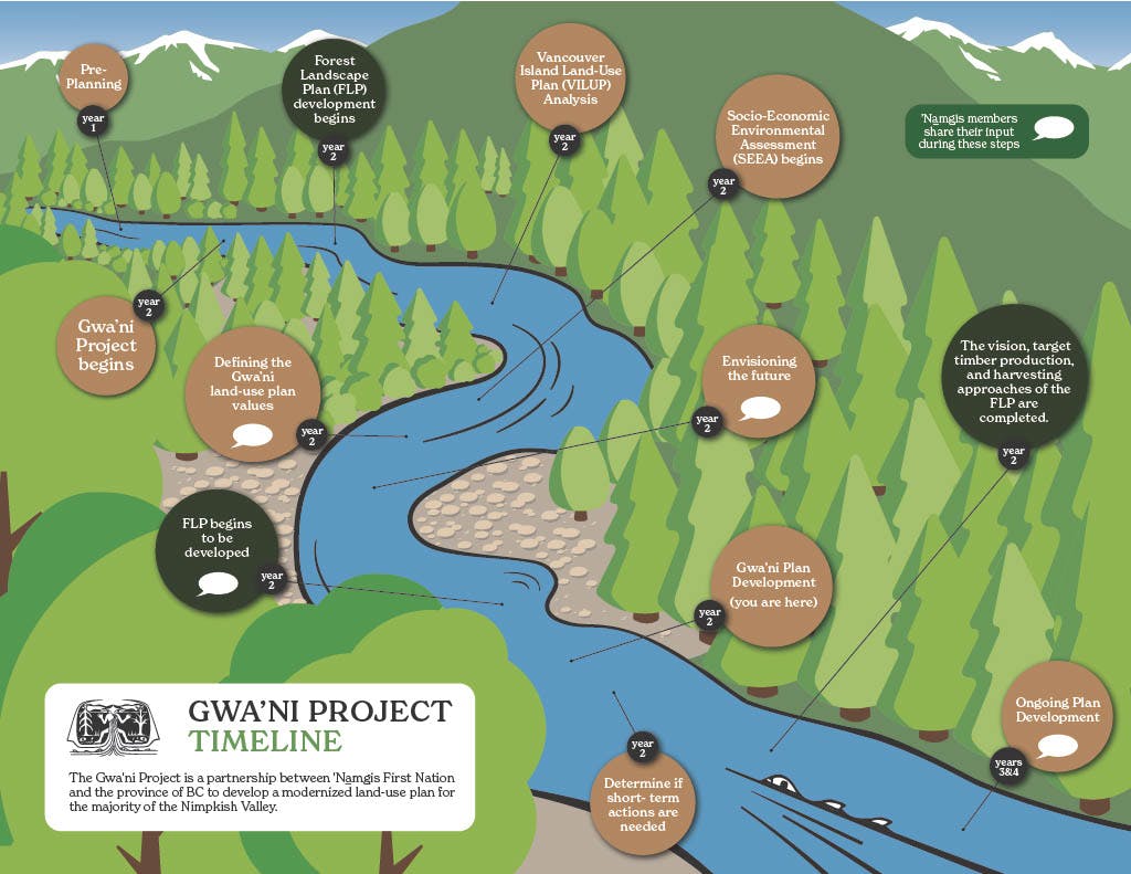
Based on this direction, ‘Namgis has been working in partnership with the BC Government and Western Forest Products since 2021 to complete the Gwa’ni Project and Forestry Pilot for most of the Nimpkish Valley. “Gwa'ni” is what our people named the river currently called the Nimpkish. The name honours our ancestor Gwa’nalalis, who became the river. This work has involved several rounds of community engagement with ‘Namgis, including multiple open houses, focus groups, and a community survey on our land use planning values. The Gwa’ni Project resulted in joint recommendations to better protect resources including rivers, lakes, watersheds and forests in portions of ‘Namgis Territory that are in the land use plan area, while supporting a successful, sustainable forestry economy. The Forestry Pilot resulted in the collaborative development of a Forest Landscape Plan that is being delivered to the Province.
More recently, ‘Namgis began working on a collaborative forest planning project with Mosaic Forest Management which focuses on sustainable forest management based in shared values and interests. The name of this new project is T’łuładi which means "having elk".
In 2024-2025, the T’łuładi Project technical team will engage with members to build on the work we began through the Gwa’ni Project, and will focus on understanding ‘Namgis members' values and priorities related to forest planning. The T’łuładi Project will continue those discussions and learn more about the specific priorities that ‘Namgis has in the Bonanza area.
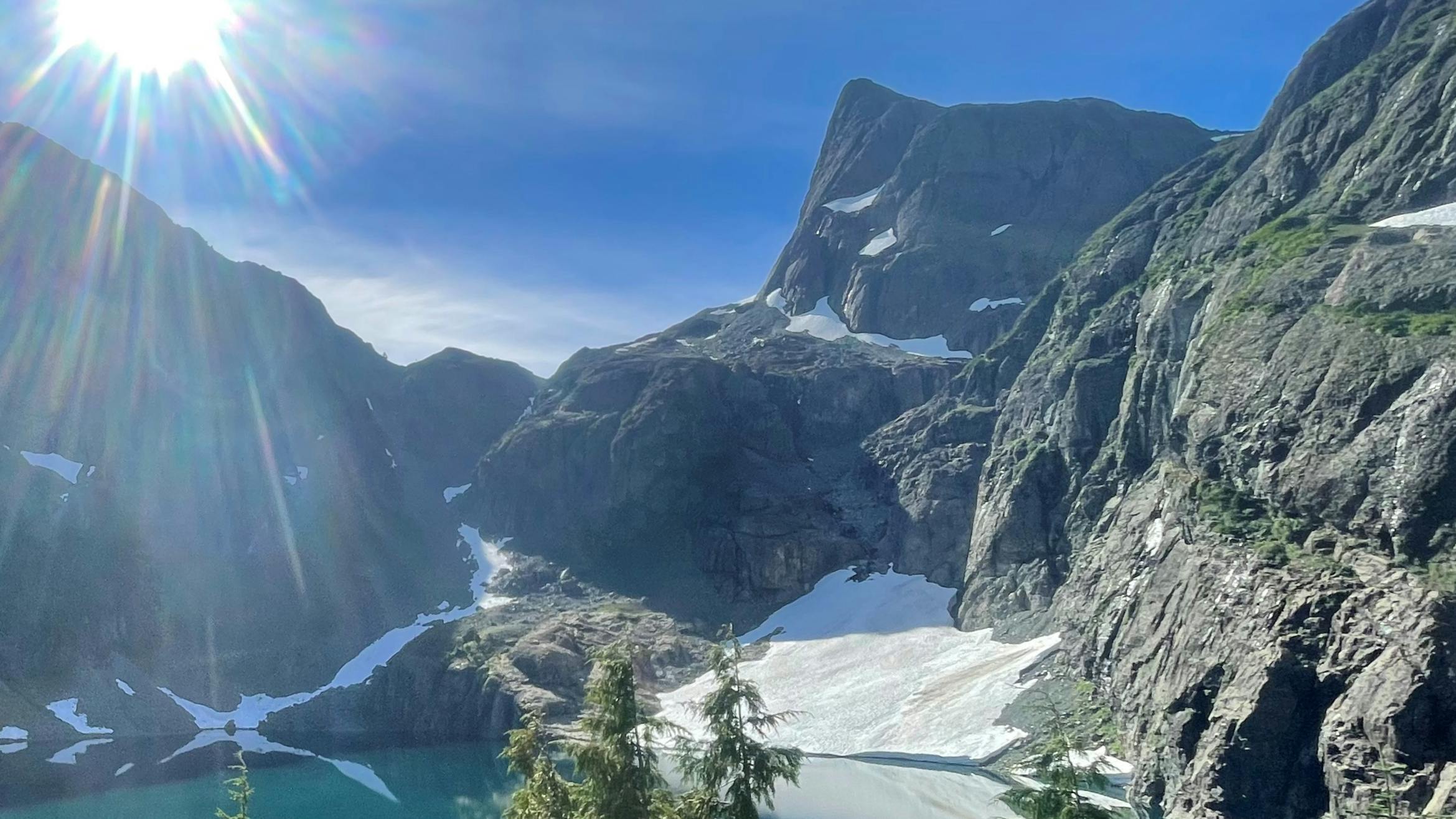
 T’łuładi Project area
The T’łuładi Project will result in a final plan intended to define joint objectives and strategies to inform good forest stewardship and sustainable resource management of the portion of Tree Farm License 47 (TFL 47) that overlaps with ‘Namgis Territory on northern Vancouver Island. This commitment aims to increase the transparency and clarity of resource planning in the overlapping area of TFL 47.
The Meaning Behind the Name "Gwa'ni"
Gwa'ni is what our people named the river currently called the Nimpkish. The name honours our ancestor Gwa’nalalis, who became the river. (Nimpkish itself is an anglicized terms referring to 'Namgis). This land-use planning project is called Gwa'ni to recognize that, for millennia, our people have been living on the lands and waters in the planning area.
Click here to read the story of Gwa'nalalis.
-
July 2022 Kala'mas: An Update on the Gwa’ni Project!
Share July 2022 Kala'mas: An Update on the Gwa’ni Project! on Facebook Share July 2022 Kala'mas: An Update on the Gwa’ni Project! on X (formerly Twitter) Share July 2022 Kala'mas: An Update on the Gwa’ni Project! on Linkedin Email July 2022 Kala'mas: An Update on the Gwa’ni Project! link
Last year, the Gwa’ni Project Team heard from members on many land use topics through the Gwa’ni Project website, a members survey and an open house. Thank you to everyone who contributed so far! If you are interested in learning more, we have combined all responses into a ‘Namgis What We Heard report, which is on the Gwa’ni Project website.
Since the Gwa’ni Project is a Government-to-Government partnership, the Province has also been engaging with stakeholders in the North Island through a survey and virtual focus groups. The responses from that engagement is available on a BC Government website in their engagement report: Gwa'ni Project What We Heard
Members of the Technical Team regularly report to, and receive feedback from, the Steering Committee, which includes leadership from ‘Namgis and the Province. This year, we are planning more engagement opportunities for members and are undertaking the third phase of a Socio-Economic Environmental Assessment (SEEA), which is an important element of the project to help decision-makers understand the potential positive and negative effects of various land use directions. In the fall of 2022, the SEEA will begin its third and final phase.
Gwa’ni Project and Forest Landscape Planning – Desired Future Forest Condition
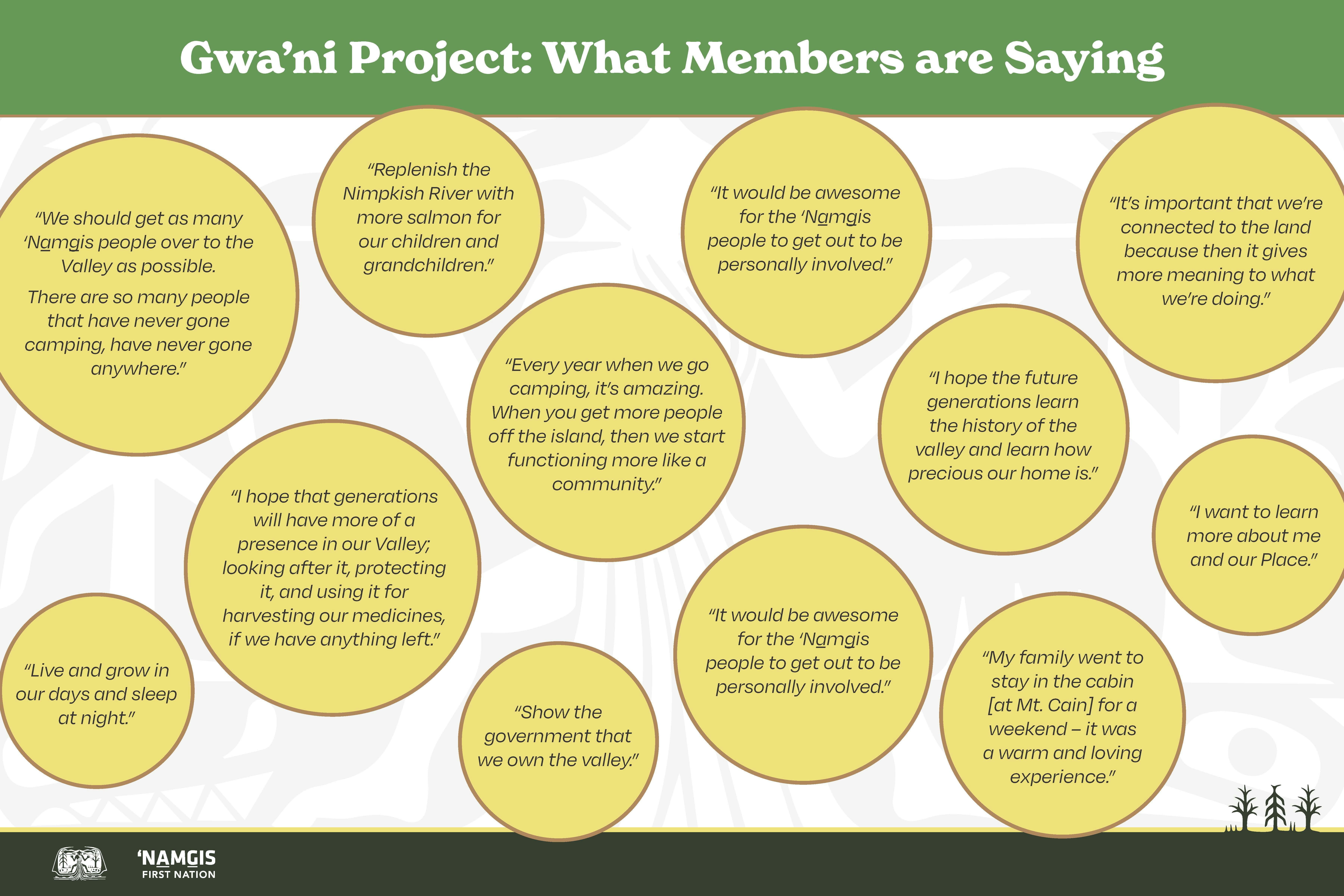
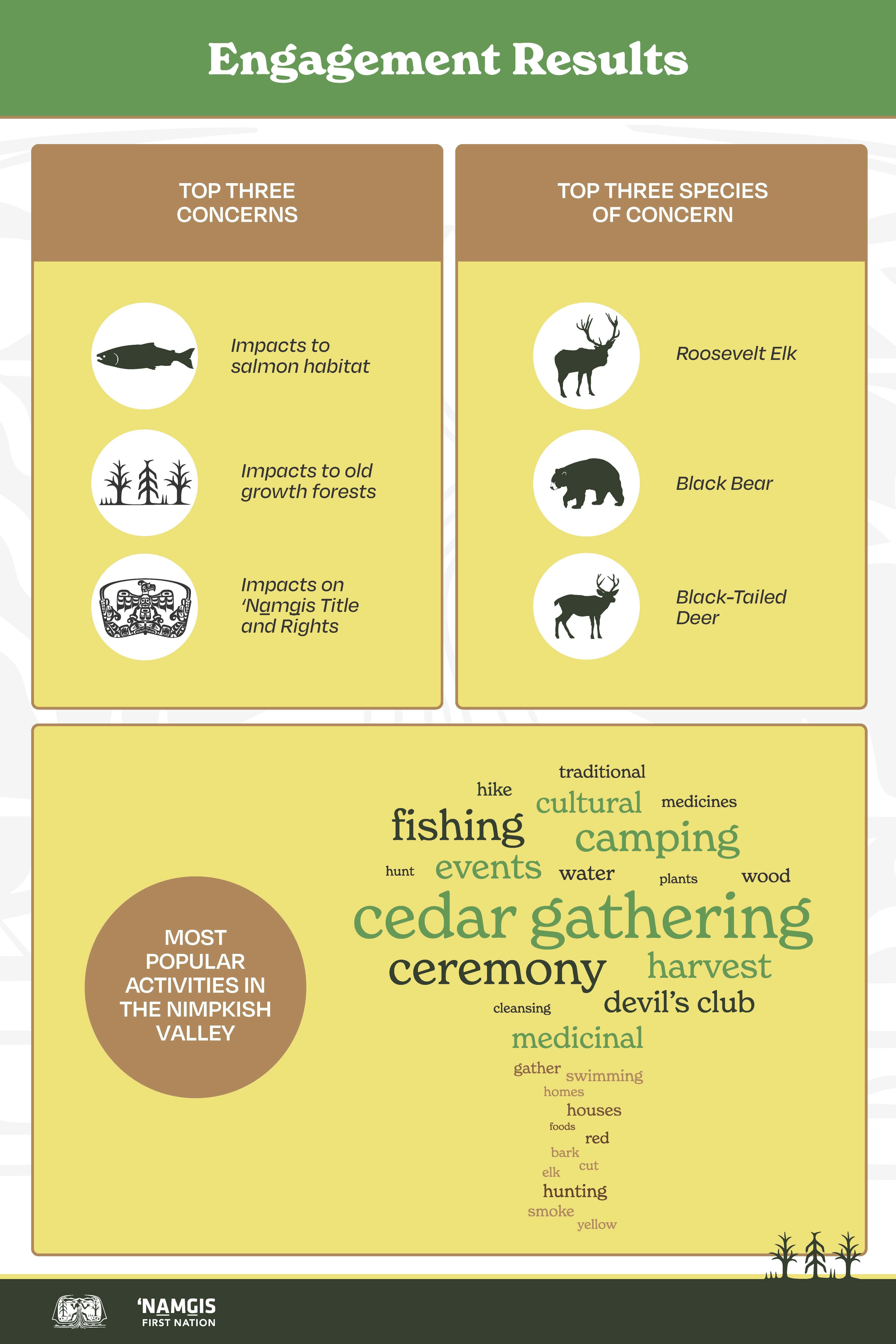
Based on the input received from members and ‘Namgis leadership; we know how important it is to recognize the cultural values of the Nimpkish Valley. More specifically, the Technical Team is considering the management of various ecosystems. Cedar is recognized as being especially precious, and trees of all ages help maintain the full natural function of the forest. The long-term availability of large cedar is important to ensure that future generations are able to harvest cedar for traditional uses such as carving poles and canoe logs.
In addition to cedar, devil’s club and other medicinal plants need to be managed to ensure they remain available for use by present and future generations of ‘Namgis, and to contribute to the health and function of the larger forest ecosystem. Once again, we want to thank everyone who took time to participate in the engagements last year to provide this crucial information. We hope that we will hear from even more people in the upcoming year.
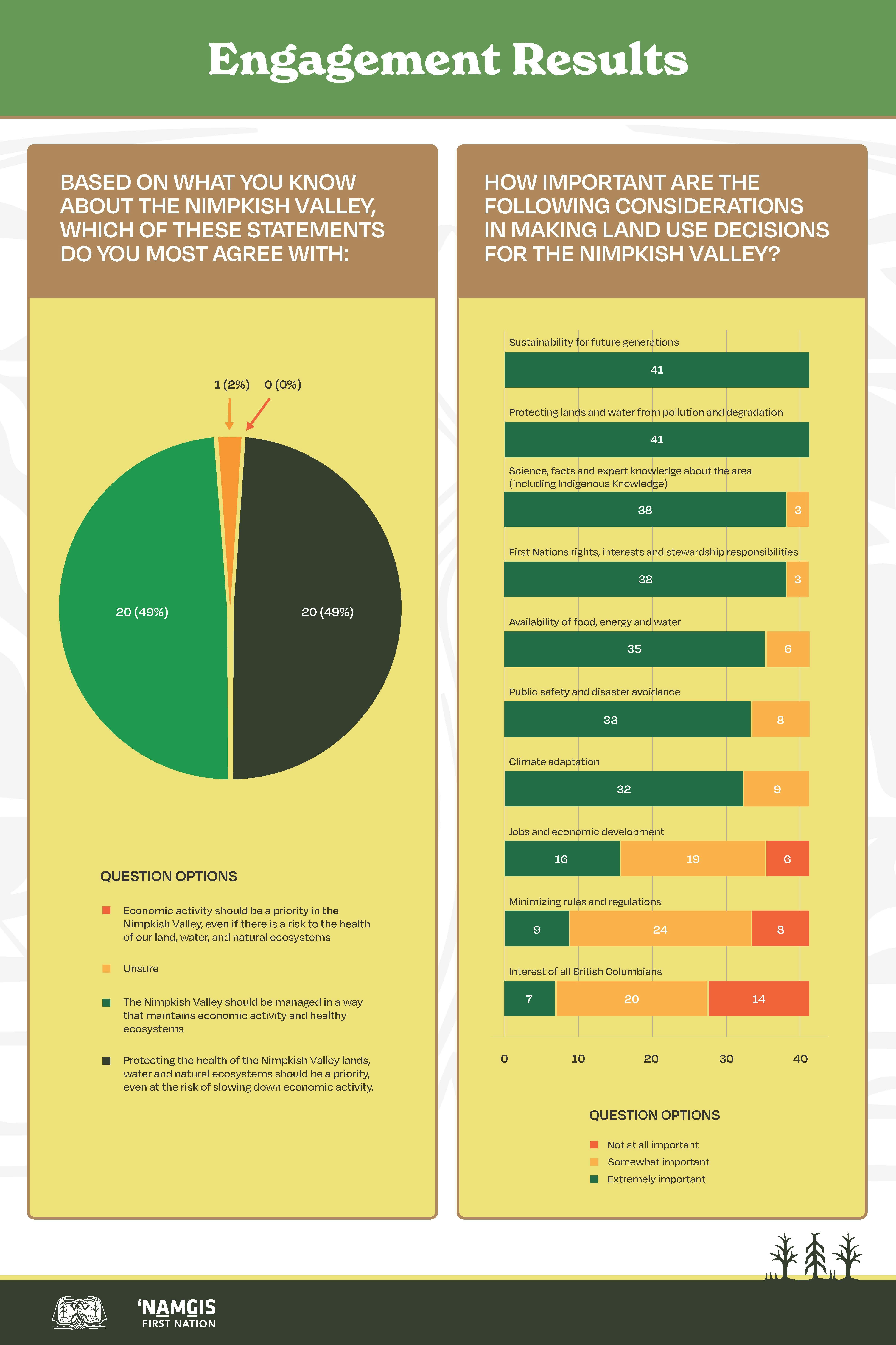
The Gwa’ni Project Team is considering the feedback that ‘Namgis members have provided about existing land use designations. The Project Team is developing recommendations that could change some zoning areas to better recognize the significance of the Nimpkish Valley’s aquatic resources, especially fish and fish habitats. The new zoning will be designed to increase the protection of forests and cultural values near streams and other types of aquatic features. Better protection of those areas will also support the resiliency of plant and animal populations by creating greater forest connectivity, which allows species to move and adapt less inhibited.
We hope you have been able to participate in the various in-person and online engagement activities that have taken place thus far, including last November’s Open House, and online through the Gwa’ni Project website!
-
End of Year Gwa’ni Project Update
Share End of Year Gwa’ni Project Update on Facebook Share End of Year Gwa’ni Project Update on X (formerly Twitter) Share End of Year Gwa’ni Project Update on Linkedin Email End of Year Gwa’ni Project Update link
The Gwa’ni Project is well underway, and a great deal of progress has been made. The Gwa’ni Project online engagement hub has been launched as a space for ‘Namgis members to go to learn about the project, share their ideas, and participate in various engagement activities.
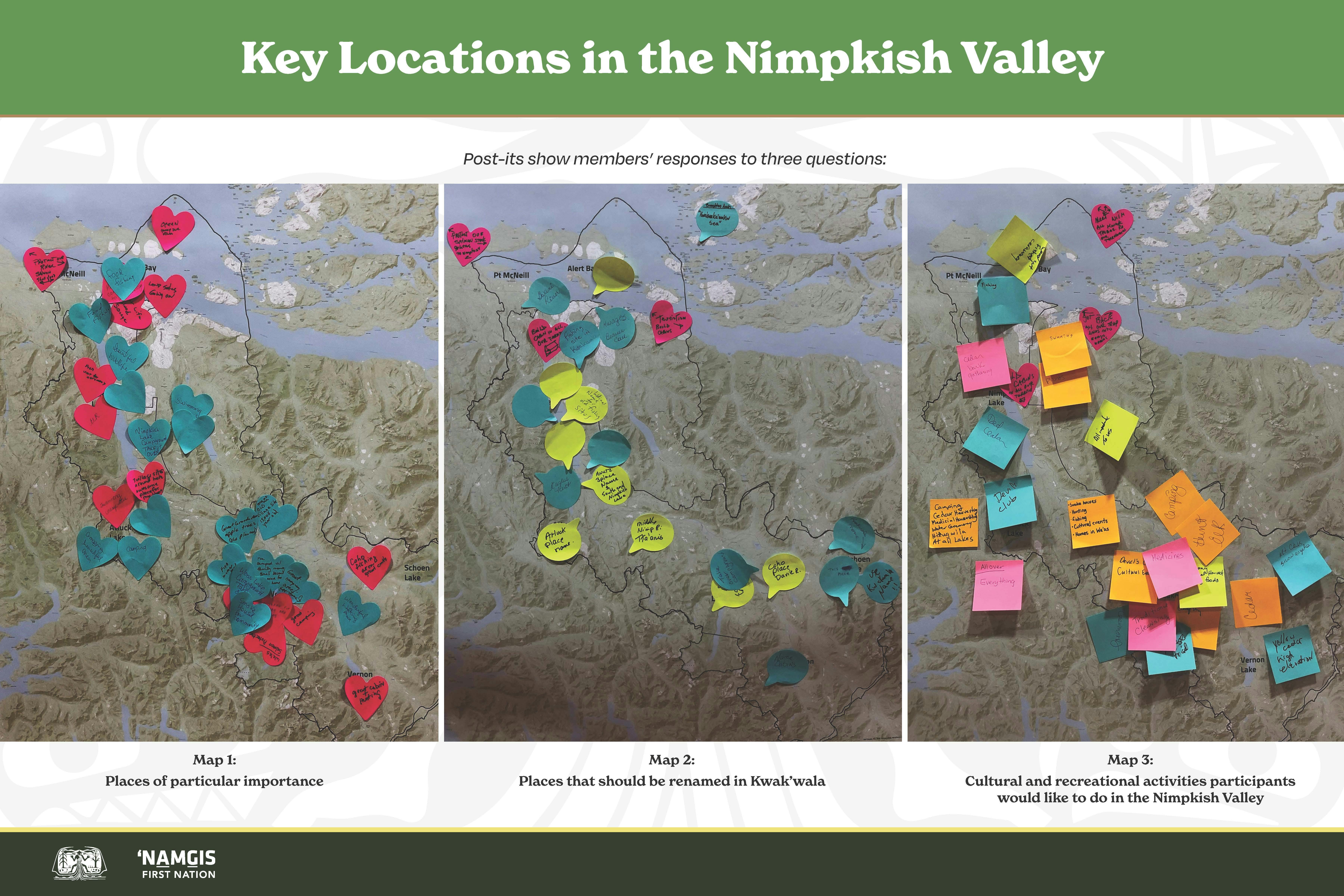
In late November, we hosted a members-only Open House for members to attend and participate in a series of engagement activities. Just about 50 people joined us on November 23 and provided important input including how they wish they could spend time in the Valley, where they think place names should be re-named in Kwak’wala and how they think land should be used in future generations. We also had a storytelling station where people could share their memories and hopes for the valley as this work continues. We also heard engaging questions from members about recreational facilities, wildlife and habitat monitoring and new or renewed programs in the valley that will help inform the Gwa’ni Project.
We are envisioning and planning for the future of the Nimpkish Valley by continuing to collect feedback from members, sharing the results of that feedback, and building upon it as we work towards a land use plan for the Nimpkish Valley.
Thank you to all members who have participated and contributed to the Gwa’ni Project thus far – your ideas are very important and valuable to the land use planning process!