'Namgis Forest Planning
During ‘Namgis comprehensive community planning, completed in 2017, we heard from members that it is crucial to develop a territorial plan and ensure that ‘Namgis is making all decisions about the use of land within the territory.
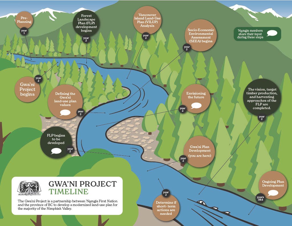
Based on this direction, ‘Namgis has been working in partnership with the BC Government and Western Forest Products since 2021 to complete the Gwa’ni Project and Forestry Pilot for most of the Nimpkish Valley. “Gwa'ni” is what our people named the river currently called the Nimpkish. The name honours our ancestor Gwa’nalalis, who became the river. This work has involved several rounds of community engagement with ‘Namgis, including multiple open houses, focus groups, and a community survey on our land use planning values. The Gwa’ni Project resulted in joint recommendations to better protect resources including rivers, lakes, watersheds and forests in portions of ‘Namgis Territory that are in the land use plan area, while supporting a successful, sustainable forestry economy. The Forestry Pilot resulted in the collaborative development of a Forest Landscape Plan that is being delivered to the Province.
More recently, ‘Namgis began working on a collaborative forest planning project with Mosaic Forest Management which focuses on sustainable forest management based in shared values and interests. The name of this new project is T’łuładi which means "having elk".
In 2024-2025, the T’łuładi Project technical team will engage with members to build on the work we began through the Gwa’ni Project, and will focus on understanding ‘Namgis members' values and priorities related to forest planning. The T’łuładi Project will continue those discussions and learn more about the specific priorities that ‘Namgis has in the Bonanza area.
 T’łuładi Project area
The T’łuładi Project will result in a final plan intended to define joint objectives and strategies to inform good forest stewardship and sustainable resource management of the portion of Tree Farm License 47 (TFL 47) that overlaps with ‘Namgis Territory on northern Vancouver Island. This commitment aims to increase the transparency and clarity of resource planning in the overlapping area of TFL 47.
The Meaning Behind the Name "Gwa'ni"
Gwa'ni is what our people named the river currently called the Nimpkish. The name honours our ancestor Gwa’nalalis, who became the river. (Nimpkish itself is an anglicized terms referring to 'Namgis). This land-use planning project is called Gwa'ni to recognize that, for millennia, our people have been living on the lands and waters in the planning area.
Click here to read the story of Gwa'nalalis.
-
April 2026: Increasing Rotation Times in Forestry
Share April 2026: Increasing Rotation Times in Forestry on Facebook Share April 2026: Increasing Rotation Times in Forestry on X (formerly Twitter) Share April 2026: Increasing Rotation Times in Forestry on Linkedin Email April 2026: Increasing Rotation Times in Forestry linkIn forestry, “rotation time” refers to the length of time trees are left to grow before being harvested. Historically, shorter rotations meant harvesting younger forests to maximize timber supply, but shorter rotations can also limit the function of wildlife habitat, reduce biodiversity, and limits the value of wood products that can be produced.
The T’łuładi Project is suggesting transitioning to longer rotation times in certain areas and types of forest within our territory. This means forests will be given more time to mature before harvesting occurs. Mature forests provide stronger wildlife habitat, greater cultural and ecological benefits, and more stable ecosystems.
Extending rotation time is a way to balance timber use with the health of the land, ensuring the forests remain productive and resilient over the long term.

-
March 2026: T’łuładi Project Zones
Share March 2026: T’łuładi Project Zones on Facebook Share March 2026: T’łuładi Project Zones on X (formerly Twitter) Share March 2026: T’łuładi Project Zones on Linkedin Email March 2026: T’łuładi Project Zones linkAs part of the T’łuładi Project, two zones are being proposed: T’ła’yi and Giwas. These are being created so that ‘Namgis can more directly guide how land is used and cared for in areas with particularly important values.
These zones are not fully closed off from resource development, but they do come with more careful planning and stronger rules. Activities within these zones will be managed to ensure that cultural, ecological, and community values are protected. Strategies that will be considered within the T’ła’yi and Giwas zones will include:
- Smaller harvest areas
- Increased retention (more trees and patches will be left standing)
- Longer rotation between harvest (allowing trees to grow older before being harvested)
These zones also help recognize that not all areas should be managed the same way. By identifying places that need additional care and attention, the project can better reflect community priorities and long-term stewardship goals.
The T’ła’yi and Giwas zones are similar to the Special Management Zones created by the Gwa’ni Project. This is another way The T’łuładi Project is moving toward land management practices that protect what matters most for ‘Namgis, now and for future generations.
-
February 2026: A Shift Away from Clear-Cutting
Share February 2026: A Shift Away from Clear-Cutting on Facebook Share February 2026: A Shift Away from Clear-Cutting on X (formerly Twitter) Share February 2026: A Shift Away from Clear-Cutting on Linkedin Email February 2026: A Shift Away from Clear-Cutting link
Clear-cutting has long been one of the most common forestry practices in our territory, but it also has very significant impacts on forests and their diverse ecosystems. Large clear-cuts can affect wildlife, reduce forest diversity, and alter landscapes for decades.
Through our forest planning work, ‘Namgis is reducing clear-cutting in certain areas, moving toward a practice called ‘retention harvesting’. This means leaving more trees behind, along edges, in clusters, or as scattered individuals, to maintain forest structure, habitat, and resilience.
This approach helps forests recover more quickly, supports ecosystems functioning, and reflects the growing priority of values beyond timber. It’s a shift toward healthier, more balanced forestry practices for today and for future generations.
-
February 2026: A New Approach to Forest Values
Share February 2026: A New Approach to Forest Values on Facebook Share February 2026: A New Approach to Forest Values on X (formerly Twitter) Share February 2026: A New Approach to Forest Values on Linkedin Email February 2026: A New Approach to Forest Values link
Forestry planning is evolving. Timber has typically been the focus of this work, but with more ‘Namgis involvement, emphasis is being placed on a broader set of values such as ecological health, cultural priorities, and long-term sustainability. This means that our forestry activities will be shaped by more than just timber harvesting, ensuring that the land will support the needs of future generations.
Based on work that has been done since 2021, Enhanced Forestry Zones are being removed from the Gwa’ni Project area, and in the Bonanza area, it is expected that similar changes will occur. For example, clear cuts larger than 40ha with reduced green up requirements for adjacent blocks will not be proposed. This means that harvested areas will be smaller, and trees in adjacent areas must reach a certain height before logging can occur.
Why does this matter? It’s part of a broader shift toward planning that balances forest use with ecological and cultural values. These changes are designed to protect ecosystem health and create a more balanced approach to land use.
-
January 2026: T’łuładi Project: Future Forest Outcomes
Share January 2026: T’łuładi Project: Future Forest Outcomes on Facebook Share January 2026: T’łuładi Project: Future Forest Outcomes on X (formerly Twitter) Share January 2026: T’łuładi Project: Future Forest Outcomes on Linkedin Email January 2026: T’łuładi Project: Future Forest Outcomes link
-
December 2025: Fun Facts about the Bonanza Area
Share December 2025: Fun Facts about the Bonanza Area on Facebook Share December 2025: Fun Facts about the Bonanza Area on X (formerly Twitter) Share December 2025: Fun Facts about the Bonanza Area on Linkedin Email December 2025: Fun Facts about the Bonanza Area link
-
November 2025: Do you know the differences between wilkw (redcedar) and dixw (yellow cedar)?
Share November 2025: Do you know the differences between wilkw (redcedar) and dixw (yellow cedar)? on Facebook Share November 2025: Do you know the differences between wilkw (redcedar) and dixw (yellow cedar)? on X (formerly Twitter) Share November 2025: Do you know the differences between wilkw (redcedar) and dixw (yellow cedar)? on Linkedin Email November 2025: Do you know the differences between wilkw (redcedar) and dixw (yellow cedar)? link
-
Fall 2025: T’łuładi Project Community Open House
Share Fall 2025: T’łuładi Project Community Open House on Facebook Share Fall 2025: T’łuładi Project Community Open House on X (formerly Twitter) Share Fall 2025: T’łuładi Project Community Open House on Linkedin Email Fall 2025: T’łuładi Project Community Open House link
The T’łuładi Project Team is inviting all members to join the upcoming T’łuładi Project Open House! This is a chance to learn more about forest planning in our territory, share your thoughts, and ensure that your voice is heard.
📅 October 28, 2025
🕔 5-6:30pm: Dinner & Introductory Presentations
🕣 6:30-8pm: Open House & Activities
📍 Lawrence Ambers Memorial Rec Centre, Alert BayDinner will be provided, and all attendees have the chance to be entered into a draw for a grand prize.
We’ll be gathering for an evening of discussion, community engagement, and learning about the T’łuładi Project. Your feedback is crucial in this process, and we want all members to be a part of it.
-
July 2025: The role of Site Series in shaping forest ecosystems
Share July 2025: The role of Site Series in shaping forest ecosystems on Facebook Share July 2025: The role of Site Series in shaping forest ecosystems on X (formerly Twitter) Share July 2025: The role of Site Series in shaping forest ecosystems on Linkedin Email July 2025: The role of Site Series in shaping forest ecosystems linkNot all parts of a forest are the same, even within the same Zone, there are subtle differences in plant life and environmental conditions. These differences are known as Site Series.
What’s a Site Series?
A Site Series is a way to describe small differences in moisture and nutrients within an ecosystem zone. It helps us understand why one area is rich in ferns and salmonberry, while another nearby patch only supports Labrador tea, moss and stunted trees. Our ancestors would have great knowledge of these site characteristics, as each one would provide different foods and medicines at different times of the year.
These Site Series traits occur from:
- Elevation: Higher elevations tend to be cooler and wetter.
- Slope and aspect: South-facing slopes receive more sunlight and are typically drier, while north-facing slopes stay cooler and moister. The steepness of the slope can also impact water and nutrient availability by affecting the drainage.
- Soil depth and nutrient content: Variations in soil characteristics affect plant growth. Shallow soils do not retain moisture very well and are generally colder which impacts the growth of trees and plants.
- Water drainage: Sites across the Territory may vary from wet and swampy organic soils to well-drained mineral soils, influencing vegetation types, tree species and growth rates.
Why do Site Series matter?
Each Site Series supports different cultural and ecological values, and can span over 50 hectares in size. Some areas are rich in food and medicine plants, while others may be important habitat for wildlife. Understanding the Site Series of these ecosystems is crucial for effective forest management, Old growth restoration, and identifying areas important for cultural practices. Even small changes in soil and slope can impact which species thrive and by recognizing these patterns and understanding how all these things are connected, we can better care for the land. Similar to the larger ecosystems, we want to ensure these individual site series and their associated, unique plant communities are represented as appropriate proportions of conservation networks across the territory.